Blizzard, dangerous wind chills strike Red River Valley
FARGO (KVRR) – Brutally cold weather could prove a deadly challenge Saturday amid a continuing wave of Arctic storms that has hammered much of the country with blinding snow, freezing rain and whipping winds.
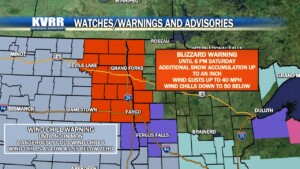
A Blizzard Warning for blowing snow is in effect for much of the Red River Valley and set to expire at 6 p.m. Saturday.
Authorities issued travel advisories for northeast North Dakota and northwest Minnesota Saturday morning.
The National Weather Service on Friday warned that a powerful storm would rock the Midwest to the Great Lakes through Saturday with heavy snow, strong winds and blizzards. Dangerously frigid weather would follow across the Rockies and the Plains, while heavy rain across the Northeast and Mid-Atlantic would threaten river and coastal flooding.
The forecast for the Fargo-Moorhead area calls for cloudy skies and lows in the double digits below zero Saturday night.
Dangerously cold wind chills between -40°F and -60°F will continue through today into Sunday for eastern North Dakota and the Red River Valley. Wind chills as low as -35°F will extend into northwest and west central Minnesota.
Blizzard conditions are confined to open country. These conditions are forecast to improve after 6:00 p.m.
On Sunday and Monday, it will be partly cloudy and still very cold with highs in the single digits below zero.