National Weather Service

Roads Closed, Travel Not Recommended During Winter Storm

In North Dakota, eastbound lanes of I-94 from Jamestown to Fargo and westbound lanes from Fargo to Valley City are closed.

FARGO, N.D. (KFGO/AP) – A wintry mix of snow, sleet and gusty winds is closing schools and making travel treacherous in parts of the Upper Midwest. In North Dakota, eastbound lanes of I-94 from Jamestown to Fargo and westbound lanes from Fargo to Valley City are closed. The North Dakota Department of Transportation (NDDOT) along with the North Dakota Highway Patrol…

Snow Forecast For Northern North Dakota

Parts of northern North Dakota could see up to 4 inches of snow.

BISMARCK, N.D. — Parts of North Dakota are likely to see measurable snowfall by the end of the workweek. KVRR Weather Authority meteorologists along with the National Weather Service forecasts a mix of rain and snow to develop Thursday afternoon across southern North Dakota and spread northward, changing to all snow Thursday night. Parts of northern North Dakota could see up…

Tornado Captured By Cell Phones In Beltrami County Wednesday Night

There have been no reports of significant damage

BELTRAMI COUNTY, Minn. — A scare last night for people living in central Beltrami County. A number of people captured video of a tornado near Ponemah. It also touched down near Red Lake. One person caught what looked like a bigger funnel forming over Lower Red Lake. There have been no reports of significant damage. The National Weather Service is…

EF 1 Tornado Knocks Down Trees And Power Lines In Bemidji

Beltrami County emergency management director says about 12 city blocks were affected

BEMIDJI, Minn. –National Weather Service confirms that it was a tornado that did damage in Bemidji. The Beltrami County emergency management director says about 12 city blocks were affected during the severe weather event. The E-F-1 tornado with winds of 90 to 100 miles per hour hit the city around 6:30 this morning. Several trees and power lines were knocked…

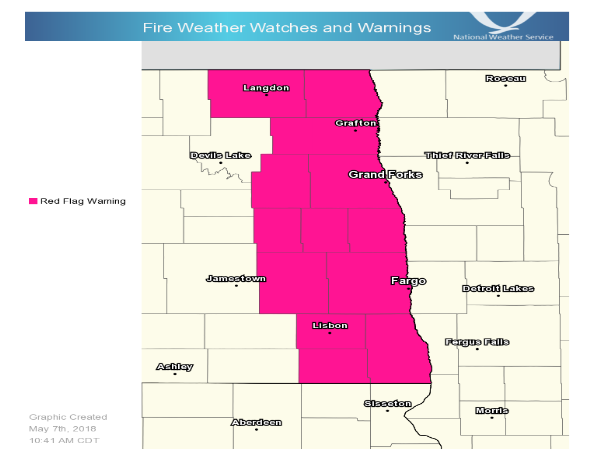
Red Flag Warning Issued Due To Windy And Dry Conditions

"Very High" Fire Danger Category In Western Minnesota

The National Weather Service in Grand Forks and the Minnesota DNR are warning about the potential for grass fires to spread rapidly. Dry grasses, dry humidity and winds gusting 25 to 35 miles per hour are combining to create critical fire weather conditions. Winds are strongest across southeast North Dakota leading to a Red Flag Warning. Most of our Minnesota…

Minnesota Snowfall Was Historic

The National Weather Service says the 14.9 inches at Minneapolis airport from Friday through Sunday set a record for the largest April snowstorm ever there.

MINNEAPOLIS – Records fell as an April snowstorm blanketed the Upper Midwest. The National Weather Service says the 14.9 inches at Minneapolis airport from Friday through Sunday set a record for the largest April snowstorm ever there. It’s also the snowiest April on record in the Twin Cities. And it’s the snowiest start to a calendar year there, with 70.3…

Snow Reports from March 25th Winter Storm

East Grand Forks reportedly received 12 inches of snow

PRELIMINARY LOCAL STORM REPORT…SUMMARY NATIONAL WEATHER SERVICE EASTERN ND/GRAND FORKS ND 942 PM CDT SUN MAR 25 2018 ..TIME… …EVENT… …CITY LOCATION… …LAT.LON… ..DATE… ….MAG…. ..COUNTY LOCATION..ST.. …SOURCE…. ..REMARKS.. 0100 PM HEAVY SNOW GRAND FORKS 47.92N 97.07W 03/25/2018 M2.0 INCH GRAND FORKS ND OFFICIAL NWS OBS STORM TOTAL THROUGH 1 PM. 0100 PM HEAVY SNOW GRAND FORKS 47.92N 97.07W 03/25/2018…

Snow Totals – February 22nd into February 23rd

Snow Totals from across the Dakotas and Minnesota

Richville, MN – 7.0″ Menahga, MN – 6.5″ Badoura, MN – 6.3″ Fergus Falls, MN – 6.0″ Park Rapids, MN – 6.0″ Bluffton, MN – 5.5″ Cormorant, MN – 5.0″ Dunvilla, MN – 5.0″ Nimrod, MN – 5.0″ Deer Creek, MN – 5.0″ Havana, ND – 5.0″ Westbury, MN – 5.0″ Sebeka, MN – 5.0″ Vergas, MN – 4.8″ Abercrombie,…

Several Towns in the Region Damaged in Tuesday’s Severe Weather

Damage in Hillsboro showed winds up to 100 miles per hour, but the tornado did not pass through town

REGIONAL — A National Weather Service storm damage assessment team says Tuesday’s severe weather in the northern and central parts of the Red River Valley produced at least three separate tornado tracks. Preliminary findings show EF-O damage between Larimore and Northwood. As the storm tracked to the southeast, EF-2 damage was reported between Buxton and Cummings, with wind speeds up…

National Weather Service Confirms Several Tornadoes

The strongest of Tuesday's storms produced EF-2 rated damage near the towns of Buxton and Hillsboro

GRAND FORKS, N.D. — The National Weather Service determined that Tuesday evening’s thunderstorms produced at least three separate tornadoes. The most intense damage from the tornadoes was rated EF-2 and occurred between Buxton and Cummings, with wind speeds of up to 135 mph. EF-0 damage was also reported between Larimore and Northwood, with wind speeds of up to 85 mph….